In my career as an Environmental Officer and later as a Scientist I have attended many public meetings where water levels were the primary issue. It is nearly impossible to make any gains at such a meeting because there are always exactly half of the people who want the water levels higher and exactly half that want them lower. Its all about the docks…right? OK so here’s the thing, although the regulatory agencies do consider multiple uses, the finer details are almost never about your dock.
If the water levels on your lake or river go up and down to a considerable degree, it is because a structure to hold back the water has been constructed somewhere downstream. Now I know what you are going to say, “Water levels naturally go up and down.” And that is correct but if you visit an uncontrolled lake in a natural environment you can see how far the water levels fluctuate by looking at the shoreline, and its not that much. It might be different in Arizona, but we are not in Arizona.
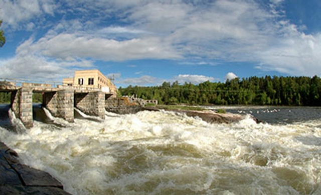 Hydro generating structures at the Norman Dam. (H2Opower.com)Lakes in the Rainy-Lake of the Woods basin have fluctuating water levels mostly because of hydroelectric generating stations or because of smaller dams that store water on behalf of the bigger ones.
The folks who operate water level structures are required to maintain seasonal water levels between acceptable levels. These water level regulations are described by rule curves or by the mandate of a control board. The water levels on a given date are maintained between identified upper and lower limits (fingers crossed). An example of a rule curve for Rainy Lake is shown in Figure 1. The blue line shows the water levels and the dashed lines show the upper and lower levels which are described by the rule curve.
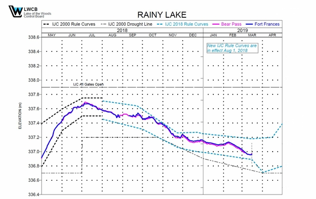 Figure 1. Recent water levels at Fort Frances and Bear Pass compared to the rule curve upper and lower levels (dotted lines).
These water level regulations are an interesting process and there is a huge amount of good information on the websites of the control boards and H2O Power which owns and operates 10 hydroelectric generating stations and 2 control dams.
https://www.lwcb.ca/regulation/LWCBStrategy2019Mar12.pdf
The various dams in the watershed together with monitoring stations for precipitation and water levels that are required to keep things operating smoothly are shown in Figure 2.
Water level regulations are designed to stabilize water levels that are agreeable for multiple stakeholders which includes aspects of water storage and elements of ecosystem integrity for the benefit of fish and wildlife. You are automatically included as a stakeholder if you love being supplied by electricity.
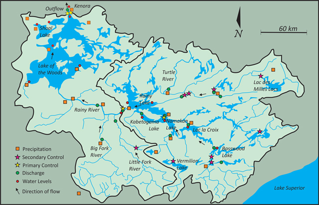 Figure 2 – Showing primary and secondary water control structures and monitoring stations for precipitation and water levels.Rainy Lake, Namakan Lake and the Seine River together with Lake of the Woods and many other water bodies form the Rainy-Lake of the Woods watershed. Rainy Lake and Namakan Lake are regulated by the International Joint Commission (IJC) and Lake of the Woods is overseen by the Lake of the Woods Control Board. In a recent review of the Rainy-Namakan rule curve, the studies that were put in place considered the observed differences between the 1970 and 2000 rule curves to help with the establishment of newer rule curves in 2018. There were many different studies including:
- Comparison of flows and levels
- Models comparing habitat for fish and wildlife
- Measuring changes in the benthic community (bottom organisms)
- Differences in aquatic vegetation between rule curves
- Measures of pike habitat between rule curves
- Comparison between nursery habitats for sturgeon, walleye and log perch
- The economic impact of rule curves on tourist resorts
- The effects of flooding and ice
- Effects on loon reproductive success
- Detailed depth mapping of nearshore areas
- Effects on cultural resources
- Effects on marsh nesting birds and herptile habitat
- Effects on Rainy River mussel community
- Assessment of fish index of biotic integrity
- Effects on walleye spawning habitat
- Effects on municipal water treatment
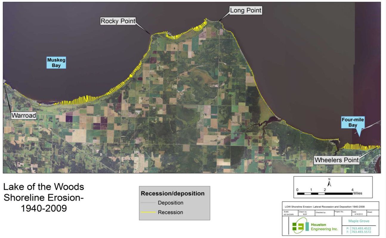 Figure 3 – Showing areas of shoreline loss between 1940 and 2009 (yellow lines) and areas of deposition (grey lines).Phew, they are clearly serious about investigating the effects of messing with water levels but you might notice that there’s not much in there about our docks. That is because our worries are not always part of the greater worry. Figure 1 shows the time where the new rule curve came into play in 2018.
In the end it is not always possible to address every concern. As an example, water level fluctuation can cause problems with erosion and sediment transport. This is partly a consequence of the precipitation that causes the water levels to go up in the first place. Erosion can produce sediment which can cause degradation of fish spawning habitat and add unwanted nutrients to the water. In more severe cases it can erode shorelines and lead to loss of shoreline property. Shoreline and bank erosion have been studied intensively especially in the southern portions of Lake of the Woods. A 2013 report (Lake of the Woods Sediment & Nutrient Budget Investigation) quantified erosion and deposition and translated these into phosphorus loads to the lake. It showed that water levels and erosion have been fairly consistent over the past 70 years as have wind direction and wind speed. It showed that there are differences between how much is lost compared to how much is deposited in recent years. This means that the loss and gain dynamic may not be the same from year to year. It is interesting to see their figure which shows areas lost and gained (Figure 3). It is important to note that none of this is related to increasing or decreasing water levels over time but it is definitely a result of fluctuating water levels at the seasonal time scale.
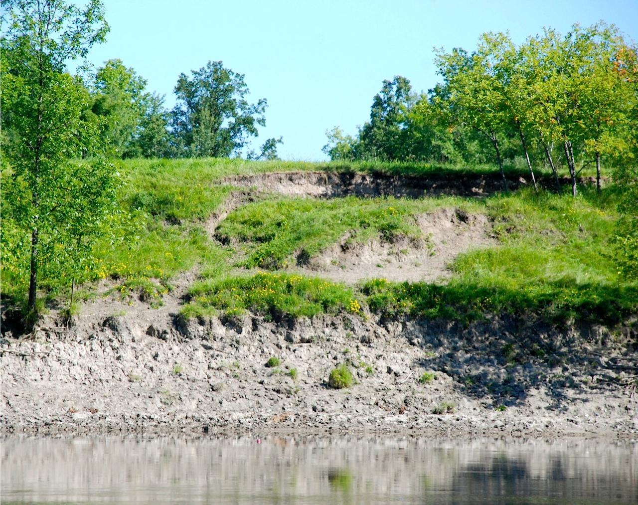 Photo: Erosion on the Rainy River. Lee Grim
Thankfully there are many efforts in place to help minimize erosion and organizations such as soil and water conservation agencies actively involve citizens to ameliorate soil loss and sediment transport. This is an improvement from the days when people sunk old rusty cars into the riverbanks to try to stabilize them. Not sure how well that worked…
So, looking back to when the first Neanderthals and possibly even their ancestors discovered that lakes have outflows, they figured out shortly afterwards that if you throw stones in there the lake level will remain higher. If you take stones out the water level will go down. They also figured out that regardless of what they did there was going to be half of the other cave people who were not happy. They maybe should have seen this coming.
This article was written for the Lake of the Woods Water Sustainability Foundation.