Originally published in the Kenora Miner and News on: July 10, 2019
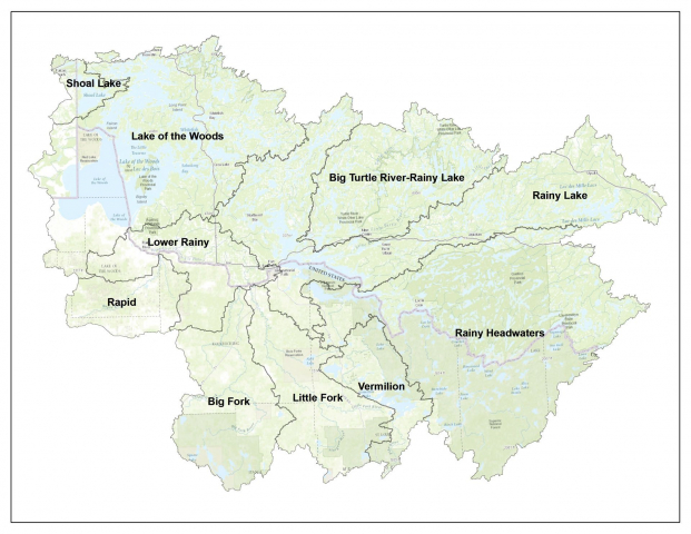 The Rainy-Lake of the Woods Watershed comprises an area of roughly 69,750 sq. km west of Thunder BayThe Rainy-Lake of the Woods Watershed is 69,750 sq. km, roughly 400 km east to west and 260 km north to south. About 41 per cent of the watershed is in the U.S. and 59 per cent is in Canada. If you’ve travelled to Atikokan or Upsala in Ontario or Ely or Cook in Minnesota, you were still in our watershed. If you’ve paddled the Turtle River in Ontario or fished in Vermilion Lake in Minnesota, you were still in our watershed. Approximately 14 per cent of the watershed is open water; where there is land, 93 per cent is covered by forest or grassland, and much of that is within provincial parks and national forests. Only 6.4 per cent of the landbase is agricultural, mostly found in the lower Rainy River area.
In our watershed, all the water flows towards either the Rainy River or Lake of the Woods, funnels into the Winnipeg River at Kenora and eventually reaches Lake Winnipeg. About 70 per cent of the water that flows into Lake of the Woods comes directly from the Rainy River, which of course is half in Canada and half in the U.S. This truly makes our watershed unique – water knows no boundaries and, as demonstrated naturally here, although the water comes from two countries, it meets up in one common place – right here in Kenora where our outlets steer it off to travel into another province to yet again mingle with new water.
This series is provided as part of the International Watershed Coordination Program of the Lake of the Woods Water Sustainability Foundation.
Kelli Saunders, M.Sc., is the International Watershed Coordinator with the Lake of the Woods Water Sustainability Foundation.