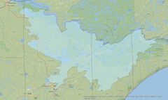
1W1P Planning AreaLocal partners including the North St. Louis Soil & Water Conservation District (SWCD), St. Louis County, Lake County & SWCD, and Cook County & SWCD are embarking on the creation of a One Watershed, One Plan (1W1P) for the Rainy River Headwaters and Vermilion River Watersheds in Minnesota. These watersheds encompass a large area of the Boundary Water Canoe Area Wilderness, Superior National Forest, Voyageur's National Park, 1854 Treaty Ceded Territory, tribal lands of the Bois Forte Band of Chippewa, and the municipalities of Ely, Orr, Tower, Winton, and many townships.
Across Minnesota, local water managers are shifting their water planning efforts from looking at county boundaries to watershed boundaries through the Minnesota Board of Water and Soil Resources (BWSR) One Watershed, One Plan (1W1P) process. Planning through 1W1P allows for a collaborate effort across jurisdictional boundaries to locally prioritize issues, target implementation activities, and create measurable goals.
The process also enables connecting the locally led plan to state strategies with state agencies providing input along the way. The comprehensive plan will cover water issues from water quality to water quantity as well as groundwater, surface water, drinking water, recreation, habitat and other concerns locally identified as important. The process will “kick-off” this summer with events across the expansive planning area and end with a locally adopted plan. The plan will include a targeted implementation schedule to be funded through MN Clean Water Funds as directed by the Clean Water Land & Legacy Amendment as passed by Minnesota voters in 2008.
![]()